Billions of tons of snow piled atop the Sierra Nevada Mountains can cause parts of the Central Valley, just west of the range, to sink – muddling groundwater assessments that take sinking as a sign of depleted aquifers. A recent Stanford University study is now offering a way to account for this heavy mountain snowpack and more accurately gauge groundwater levels.
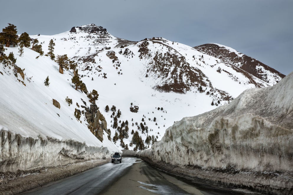
As snowfall piles up in the Sierra, as occurred in historic fashion this past winter, it causes the ground in the valley below to sink. (Image credit: George Rose / Getty Images)
Analyzing satellite-based measures of surface changes over time has emerged as a promising method for monitoring groundwater in places such as the agriculturally rich Central Valley, where farmers rely heavily on groundwater to irrigate crops in dry years. But the method requires a clear understanding of the true mechanisms behind any observed elevation changes.
The new study, published April 28 in Geophysical Review Letters, shows how heaped-up snow and ice in the Sierra during California’s wet season depresses the valley floor, accounting for the majority of the detected elevation change in 60% of the valley. As tens or even hundreds of feet of snowfall pile up in the Sierra, as occurred in historic fashion this past winter, it causes the ground in the valley below to sink by anywhere from a tenth of an inch to an inch.
Although scientists have long suspected that snow and ice in nearby mountains could throw off groundwater assessments tied to elevation changes, they lacked a way to quantify the effect. “We’ve shown for the first time how to disentangle, decouple, and ultimately isolate the two effects of elevation changes due to groundwater levels and snowpack loading,” said lead study author Seogi Kang, a postdoctoral fellow in geophysics at Stanford.
“With improved understanding of the hydrogeophysics at play here, we can help ensure the Central Valley’s agricultural productivity remains sustainable.”
—Seogi Kang
Postdoctoral Fellow in Geophysics
Failing to properly account for the effect of snowpack loading could lead groundwater managers whose decisions are increasingly informed by elevation-based monitoring methods to underestimate actual water levels.
“With the weather extremes of flooding and drought becoming more common due to climate change, coupled with the challenge of ensuring the long-term sustainability of our groundwater resources, it is critical that we provide groundwater managers with the newest technologies and insights,” said study senior author Rosemary Knight, a professor of geophysics in the Stanford Doerr School of Sustainability. “This study is an important step forward in giving groundwater managers a new way of using satellite data to accurately monitor the volume of stored groundwater in the Central Valley.”
The view from on high
For the study, Kang and Knight pored over five years of elevation data gathered using a technique known as interferometric synthetic aperture radar, or InSAR, which works by measuring how long it takes radar signals to bounce back to a satellite from a series of precise locations on the ground at different times.
Analyzing these data over time can reveal information about underground water resources because subsurface layers of sediments and clay act like a sponge. If groundwater pumping for irrigation and drinking water depletes an aquifer, it’s like squeezing out the sponge: The layers compact and can cause the ground surface to sink.
The InSAR dataset used for the new study spans nearly all 18,000 square miles of the Central Valley, with measurements taken once per week on average between 2015 and 2019. The resolution isn’t perfect – each datapoint represents elevation across an area roughly equivalent to a football field – but it’s far better than common groundwater monitoring methods that involve drilling wells sporadically across the vast Central Valley and checking readings a few times per year.
The snowpack effect
Kang created a statistical machine learning program to sift the immense InSAR data haul into similar clusters based on the time variation in the data. These data were then compared alongside monthly average Sierra Nevada snowpack data for the same time period. “Sorting the data like this allowed us to identify the parts of the Central Valley where elevation changes are dominated by hydrological loading – what we call the snowpack effect – and which parts are dominated by the groundwater system,” said Kang.
Overall, by filling in major data gaps in the current groundwater monitoring regime using InSAR data, the Stanford researchers hope their approach can support and inform groundwater management decisions, from where and when to cap pumping to how best to allocate new water delivery infrastructure.
“So much of the food we eat and enjoy comes from the Central Valley and other places that face significant water supply challenges,” said Kang. “With improved understanding of the hydrogeophysics at play here, we can help ensure the Central Valley’s agricultural productivity remains sustainable.”
Knight is the George L. Harrington Professor at Stanford and a senior fellow in the Stanford Woods Institute for the Environment.
The research was funded in part by the Gordon and Betty Moore Foundation and the NASA Applied Sciences Water Resources Program in the Earth Science Division.
To read all stories about Stanford science, subscribe to the biweekly Stanford Science Digest.
Media Contacts
Seogi Kang, Stanford Doerr School of Sustainability: sgkang09@stanford.edu
Rosemary Knight, Stanford Doerr School of Sustainability: rknight@stanford.edu
Josie Garthwaite, Stanford Doerr School of Sustainability: (650) 497-0947, josieg@stanford.edu
Author
Adam Hadhazy