Researchers in the Stanford Radio Glaciology lab use radio waves to understand rapidly changing ice sheets and their contributions to global sea-level rise. This technique has revealed groundwater beneath Greenland, the long-term impacts of extreme melt, a process that could accelerate ice sheet mass loss in Antarctica, the potential instability of an ice sheet that could raise sea levels by 10 feet, and more.
Now, PhD students within the group have created an open-source tool that others can use to make ice-penetrating radar systems, core instruments in the field of glaciology. The Open Radar Code Architecture (ORCA) offers scientists a cheaper, easier, and more efficient way to build both airborne and ground-based radars, even if they lack a technical engineering background. Ice-penetrating radars can cost tens or hundreds of thousands of dollars, while the lowest-cost version of the team’s open-source radar costs only $1,500.
“We’re enabling groups to build exactly the right instrument for what they’re trying to do,” said PhD student Thomas Teisberg, who developed the system along with Anna Broome, PhD ’24.

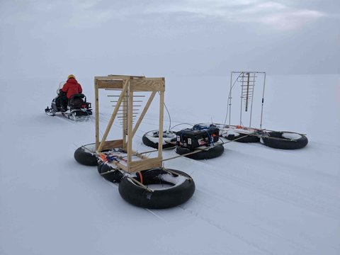
Anna Broome pulling the radar/radiometer she built using ORCA behind a snowmobile near Summit Station in Greenland. | Thomas Teisberg
Whereas previous radar systems were built with specific hardware components specialized for each use case, the new model’s hardware components specialized for each use case, the new model’s hardware is generic and more easily reconfigured depending on the task at hand. Broome likens the design to a kitchen mixer, with a variety of attachments available depending on what you’re planning to make. By standardizing the basic building blocks of what that radar looks like, Broome and Teisberg have also created a uniform format to store data so glaciologists can effectively reuse each other’s data.
“I think we’re going to see some really exciting and first-of-their kind experiments enabled by this system,” said Principal Investigator Dustin Schroeder, an associate professor of geophysics at the Stanford Doerr School of Sustainability. Teisberg and Broome recently co-authored a study along with Schroeder in IEEE Transactions on Geoscience and Remote Sensing that offers a blueprint for building the tool.
Seeing beyond the ice
The ice sheets and glaciers atop Greenland and Antarctica are critically important, providing habitats to wildlife, storing more than half of the planet’s freshwater, and contributing to the evolution of the climate. They’re a major contributor to the sea-level rise that threatens the 680 million people who live in low-lying coastal zones – yet the uncertainty of projections may be underestimating that threat. Earth’s ice sheets represent the largest contribution to uncertainty in average sea-level rise by 2100, according to Intergovernmental Panel on Climate Change (IPCC) models.
In order to grasp current ice loss and make projections into the future, scientists need to understand the land underneath the ice and how it impacts flows and stability. “If you want to understand how ice is going to melt and change, you need to know what the bottom of the ice sheet looks like,” said Teisberg.

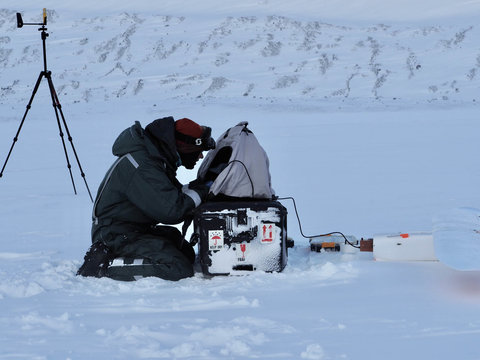
In Svalbard, Thomas Teisberg reviews a flight plan for the Peregrine UAV before launch. | Eliza Dawson
Building a toolkit
Currently, scientists use a wide range of radar instruments to gather data that is subsequently analyzed and interpreted to understand how glaciers and ice sheets work. For a scientist trying to break into the field, or for those without an engineering background, it can be challenging to figure out what radar system is best suited to an intended use case. The ORCA platform is built from software-defined radio – a type of hardware that is reconfigurable using software – democratizing the ability to design customized instruments.
“If the community embraces this new tool, I think we’ll see a lot more scientists collecting their own radar data and re-using the innards of those radar systems to study really varied parts of the ice sheet that currently you would need multiple different types of radars to observe,” said Broome, who is now an R&D electrical engineer at Sandia National Laboratories.
Ice-penetrating radar is a foundational tool for glaciologists, but until now, most systems have been built by electrical engineers, not glaciologists, explained Robert Hawley, a physical glaciologist and professor of Earth sciences at Dartmouth College whose research group uses ice-penetrating radar and builds instrumentation for the frozen components of the Earth’s system. The learning curve for building hardware is very steep, he said. “By releasing their work as open-source software, Thomas and Anna have enabled a new generation of researchers to access and build ice-penetrating radars, which will spur a resurgence in this kind of research. This enables the scientists, asking the science questions, to get involved in a way that was not previously possible.”
Collecting better data
The idea for the open-source platform arose when Broome and Teisberg were separately developing plans for radar systems that map the land underneath ice sheets.
“At some point we realized, wait a minute, we could team up and build the instruments on a common core, adapt them to our needs, and save a lot of work that way,” said Teisberg.
Ice-penetrating radar acts like other radar: It sends out electromagnetic waves and records the timing of their reflections to determine an object’s distance. Ice-penetrating radar uses lower frequencies than most other radar systems and aims those waves straight down to penetrate through the ice and provide reflections off the ice surface, as well as the bedrock or sediment sitting underneath the ice.
While the tool is straightforward, flying a crewed aircraft in Greenland is no small feat – it costs a lot of money and requires a complicated set of logistics. “Our hope is that by standardizing the core of the radar, we can still allow people to build their customizations, and we can make it much easier for people to reuse data that’s been collected. By doing that, we can extract a lot more value out of every piece of data that gets collected,” Teisberg said.
The new study includes blueprints for building the two specific instruments that Broome and Teisberg engineered for their own PhD research. Teisberg is the first to admit that they have not built a new instrument. “We are standing on the shoulders of many, many people who’ve done a lot of incredible work in this field before. We’re just making an existing type of instrument much more accessible.”
To test their prototypes, Broome and Teisberg traveled to Iceland, Svalbard, and most recently to Summit Station, the National Science Foundation-run research station at the top of the Greenland ice sheet. They confirmed their functionality by comparing results with previously acquired data from those areas – and they hope their research is just the beginning. Schroeder said the open-source tool is like a gift to the glaciology community.
“I would have loved if ORCA would have been around when I was a student,” Schroeder said. “I’m really excited about the opportunities it presents for students in my own group and for glaciology students around the world.”
For more information
Schroeder is also an associate professor of electrical engineering and a senior fellow at the Woods Institute for the Environment. Teisberg is a PhD candidate in electrical engineering in the School of Engineering. This research was supported by NASA, the NSF, NDSEG, and the Heising-Simons Foundation. Additional support was provided by the TomKat Center for Sustainable Energy, Stanford University Human-Centered Artificial Intelligence (HAI), and the Stanford Data Science industrial affiliates program. Stanford industrial affiliates programs are funded by membership fees from companies. View current members of Stanford Data Science.