One of the most striking features of Santa Catalina Island, southwest of Los Angeles, is an absence. Unlike much of the California coast and its closest islands, Catalina lacks cliffs stepping up and back from the sea – remnants of shorelines carved when the Pacific sloshed higher than it does today and fault movements had yet to push this part of the continent beyond the water’s reach.

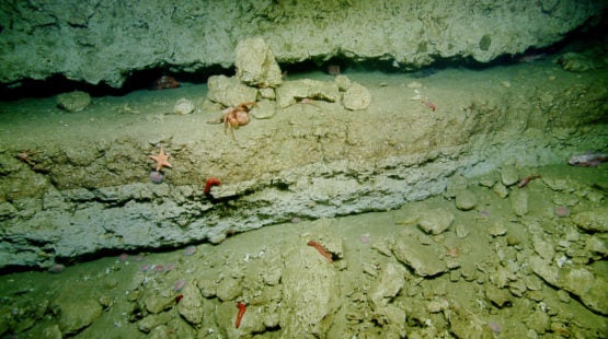
Catalina’s ancient beaches are hidden underwater at depths that have long kept them out of reach for scientists seeking to understand movement of the Earth’s crust along the continental borderland in Southern California. (Image credit: Ocean Exploration Trust)
Instead, Catalina’s ancient beaches lie hidden beneath the surf. Now, new research led by Stanford University geophysicists explains why: while most islands in southern California are inching upward, Catalina is sinking.
Scientists have debated whether Catalina is rising or sinking for more than 100 years. As recently as 2012, the U.S. Geological Survey published a paper concluding that the island was rapidly uplifting. “We’re directly contrary to their results,” said Chris Castillo, a graduate student in geophysics at Stanford’s School of Earth, Energy & Environmental Sciences (Stanford Earth) and lead author of the new paper.
“When we stop and think about it, it makes perfect sense,” said Stanford Earth geophysicist Simon Klemperer, the paper’s senior author. Picture a giant, sideways-S shaped fold in the tectonic plate boundary off the California coast. “When the faults are a little bit curved, then when the plates slide past each other, some bits are pushed up and others subside,” Klemperer said. “Half the time you should expect an island to be going down. The reason we don’t see that is most of the subsiding islands have already gone below sea level. Offshore, there are a bunch of flat-topped, submerged seamounts that used to be islands.”
The revelation is key to understanding plate tectonics and earthquake risk in the area around the San Andreas fault. “If Catalina were to change direction and start going up,” Castillo said, “that would imply a significant reorganization of the distribution of tectonic stress in southern California.” And when tectonic stress gets redistributed, it can influence ground motion and earthquakes.
The research, published in the peer-reviewed Geological Society of America Bulletin, comes amid growing urgency to understand the details and shifts of ancient shorelines, as low-lying coastal communities reckon with more frequent floods and accelerating sea level rise. As Castillo put it, “We’re living in a time when the shoreline is changing on us again.”
Send in the robots
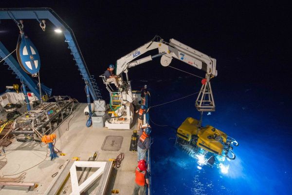
The great depths of Catalina’s terraces have long kept them out of reach for scientists seeking to understand movement of the Earth’s crust along the continental borderland in Southern California. To overcome this challenge, the researchers created a map of the marine terraces and their internal geometry using seismic data, which involves measuring how sound waves bounce off structures beneath the surface of the sea floor. Then they deployed a pair of remotely operated vehicles, or ROVs, tethered to the E/V Nautilus research vessel to verify their results.

Deck chief Mark DeRoche and the Nautilus crew supervise deployment of Hercules, a remotely operated submersible that allowed the researchers to collect samples from submerged terraces that helped to determine the age of the paleo shoreline around Catalina Island. (Image credit: Ocean Exploration Trust)
Sending instructions in real time to the Nautilus crew from onshore computers, Castillo and Klemperer piloted the robots up the island’s steep, muddy slopes starting more than a half-mile below sea level. They filled the ROVs to the brim with cores, grab samples and sediments vacuumed up from the seafloor.
Laboratory analysis of the samples they collected eventually uncovered hundreds of shells and fossils preserved in sediments nearly 1,000 feet deeper than the waters where the species are known to have lived – evidence that the land has dropped since the time of the deposits. Smooth, rounded stones found far offshore in Catalina’s oldest, deepest terraces closely resemble those shaped by waves near modern beaches. All of this points to the terraces having once been beachfront property.
What’s more, carbon dating of fossils collected from one terrace dates them back to the last ice age, which matches nearly exactly to when the group’s geophysical maps suggested that part of the island would have been much closer to sea-level, in the shallow waters where those organisms flourished.
The study builds on research Castillo first presented in 2015, which suggested Catalina was sinking and tilting at a rate that could put the island completely underwater within 3 million years. Now, with the additional carbon-dated fossil evidence included in this paper, Klemperer said, the debate over Catalina’s rise or fall should be settled. “We have absolute, 100 percent conviction that the island is currently going down.”
Tilting toward the mainland
The research shows that Catalina has sunk each decade for more than a million years by at least two millimeters – about the height of a nickel. But it is also tilting ever so slightly toward the mainland, making the island’s underwater cliffs steeper and steeper over time.

San Clemente Island, part of California’s Channel Island archipelago, displays a stair-step landscape of uplifted marine terraces. (Image credit: Dan Muhs/USGS Geosciences and Environmental Change Center)
The process is gradually raising the odds that chunks of cliff will fall in submarine landslides, which the new research reveals have occurred in Catalina’s past.
These events interest scientists because in some cases the rapid movement of seafloor sediments and rocks can wreak havoc on marine infrastructure or create significant waves. As a result, understanding the triggers and dynamics of submarine landslides can help clarify threats to deep-water energy pipelines and undersea communication cables. Studying submerged landslides can even shed light on the past climate of Mars, where deposits from landslides analogous to those on Earth can hold clues about the presence of ice or water.
Beyond Catalina
Understanding the rise and fall of terraces along the California coast has implications far beyond local communities. By zooming in and measuring meter-by-meter how sea levels have changed in relation to the land at this one site, with multiple lines of evidence over a period of more than a million years, the work could help to calibrate sea level models, improve predictions of rising seas and enable other researchers to accurately gauge the uplifting or sinking of Earth’s crust without the expense of drilling and coring. Think of it as akin to medical diagnoses that can now be made with imaging alone, without incisions to understand what lies under the skin.
“Having as many points on the path as possible really helps give us a more precise picture of global sea level over time,” Castillo said. “If we know how to mathematically model what’s happened in the past, then we can probably continue that into the future.”
Simon Klemperer is also a professor, by courtesy, of geological sciences. Co-author James C. Ingle is Stanford’s W. M. Keck Professor of Earth Sciences, emeritus. Additional co-authors are from USGS, Legg Geophysical and California State University, Long Beach.
The research was funded by the Ocean Exploration Trust, Shearwater Geoservices AS, IHS Markit, the American Chemical Society Petroleum Research Fund, Southern California Earthquake Center, Conoco-Phillips Inc., Geometrics, Subsea Systems, USGS Pacific Coastal Marine Science Center, and an NSF Graduate Fellowship.
Media Contacts
Josie Garthwaite, School of Earth, Energy & Environmental Sciences:
(650) 497-0947, josieg@stanford.edu
Chris Castillo, School of Earth, Energy & Environmental Sciences:
Simon Klemperer, School of Earth, Energy & Environmental Sciences:
(650) 723-8214, sklemp@stanford.edu