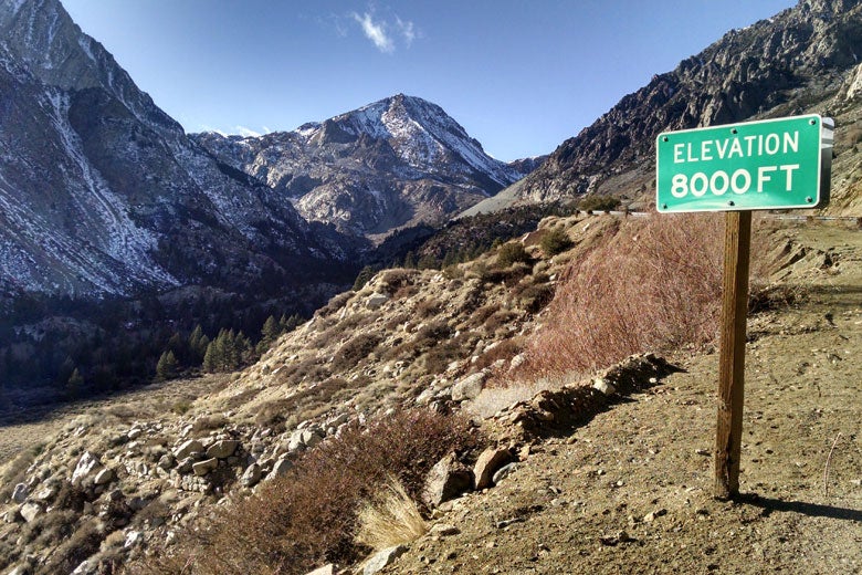
The nearly snowless Tioga Pass in January 2015 shows the dramatic effect of extremely low precipitation and record-high temperatures upon California’s critically important mountain snowpack at the height of climatological winter. (Image credit: Bartshé Miller)
Atmospheric patterns associated with droughts in California have occurred more frequently in recent decades, Stanford scientists say.
In new research published online this week in Science Advances, a team of researchers led by Stanford scientist Noah Diffenbaugh analyzed the occurrence of large-scale atmospheric circulation patterns that have occurred during California’s historical precipitation and temperature extremes.
“The current record-breaking drought in California has arisen from both extremely low precipitation and extremely warm temperature,” said Diffenbaugh, an associate professor of Earth system science at Stanford School of Earth, Energy & Environmental Sciences and a senior fellow at Stanford Woods Institute for the Environment. “In this new study, we find clear evidence that atmospheric patterns that look like what we’ve seen during this extreme drought have in fact become more common in recent decades.”
In the new study, Stanford graduate student Daniel Swain and co-authors investigated whether atmospheric pressure patterns similar to those that occurred during California’s historically driest, wettest, warmest and coolest years have occurred with different frequency in recent decades compared with earlier in California’s history. The study focused on the northeastern Pacific Ocean and far western North America, encompassing the winter “storm track” region from which the vast majority of California precipitation originates.
The researchers used historical climate data from U.S. government archives to investigate changes during California’s October to May “rainy season.” They identified the specific North Pacific atmospheric patterns associated with the most extreme temperature and precipitation seasons between 1949 and 2015. Their analysis revealed a significant increase in the occurrence of atmospheric patterns associated with certain precipitation and temperature extremes over the 67-year period.
In particular, the Stanford scientists found robust increases in the occurrence of atmospheric patterns resembling what has occurred during the latter half of California’s ongoing multi-year drought.
“California’s driest and warmest years are almost always associated with some sort of persistent high pressure region, which can deflect the Pacific storm track away from California,” said Swain, the study’s first author and a graduate student in Diffenbaugh’s lab. “Since California depends on a relatively small number of heavy precipitation events to make up the bulk of its annual total, missing out on even one or two of these can have significant implications for water availability.”
Blocking ridges are regions of high atmospheric pressure that disrupt typical wind patterns in the atmosphere. Scientists concluded that one such persistent ridge pattern – which Swain named the Ridiculously Resilient Ridge – was diverting winter storms northward and preventing them from reaching California during the state’s drought. In 2014, the Stanford researchers published findings that showed that the increasing occurrence of extremely high atmospheric pressure over this same part of the Northeastern Pacific is “very likely” linked to global warming.
The group next wanted to investigate whether the particular spatial pattern associated with the Triple-R has become more common – a question not asked in the original 2014 study. The new study provides a more direct answer to this question.
“We found that this specific extreme ridge pattern associated with the ongoing California drought has increased in recent decades,” Swain said.
Despite the fact that the number of very dry atmospheric patterns in California has increased in recent decades, the number of very wet atmospheric patterns hasn’t declined.
“We’re seeing an increase in certain atmospheric patterns that have historically resulted in extremely dry conditions, and yet that’s apparently not occurring at the expense of patterns that have historically been associated with extremely wet patterns,” Swain said. “We’re not necessarily shifting toward perpetually lower precipitation conditions in California – even though the risk of drought is increasing.”
That might sound contradictory, but it’s not, the scientists said. Imagine looking at a 10-year period and finding that two of the years are wet, two are dry and the rest experienced precipitation close to the long-term average. Now imagine another decade with three very dry years, three very wet years and only four years with near-average precipitation.
“What seems to be happening is that we’re having fewer ‘average’ years, and instead we’re seeing more extremes on both sides,” Swain said. ” “This means that California is indeed experiencing more warm and dry periods, punctuated by wet conditions.”
Funding for the research was provided by the National Science Foundation, the Switzer Foundation, the ARCS Foundation, the U.S. Department of Energy and a G.J. Lieberman Fellowship from Stanford University.
Media Contacts
Noah Diffenbaugh, Stanford University School of Earth, Energy & Environmental Sciences: (650) 223-9425, diffenbaugh@stanford.edu
Daniel Swain, School of Earth, Energy & Environmental Sciences: (415) 686-1349, dlswain@stanford.edu
Ker Than, School of Earth, Energy & Environmental Sciences: (650) 723-9820, kerthan@stanford.edu
Author
Ker Than