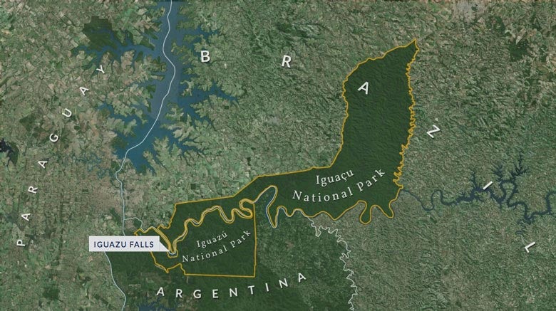
Digitized aerial images of the Iguazu Falls region help Stanford doctoral student Frederico Freitas see how national parks sharpened the border between Brazil and Argentina (Image credit: Boundaries of Nature)
Nestled along the border between Argentina and Brazil are the spectacular, thundering Iguazu Falls. Surrounding them are two national parks – legally protected areas of subtropical rainforest that appear free of both people and politics.
According to Stanford’s Frederico Freitas, however, the national parks served a more pointed purpose throughout the 20th century: They were geopolitical weapons and highly effective tools for nation-building.
Freitas, a doctoral candidate in Latin American history, is writing the first history of national parks in Brazil and Argentina. Combining untapped archival sources with the latest digital methods, Freitas offers a new account of how national parks were used to strengthen the border between the two regional rivals.
In the 1930s, Freitas explains, two national parks were established on land adjacent to the border: Iguazú National Park in Argentina, and Iguaçu National Park in Brazil. Both parks protected areas of scenic wilderness, including the world-renowned falls.
But Freitas says that the parks’ true function was geopolitical: They were used by Brazil and Argentina as national symbols, ways of laying claim to the empty land and transforming a wild, unpatrolled frontier region into a secure border.
Freitas discovered that the parks were generated not by noble environmentalism, but rather by the strategic rivalry between the two countries.
“They were created around the same time, one because of the other,” he said. “There’s this interconnected history.”
Over time, different ways of thinking about nature led to different styles of park management. Freitas’ research reveals how the border became inscribed on the landscape itself as settlements flourished on Brazilian territory.
Freitas explains that Argentineans, accustomed to the flat grasslands around Buenos Aires, saw this border region as exotic.
“They saw this as their wilderness,” Freitas said, “a very distant and alien area.”
Brazilians, on the other hand, had been settling in subtropical forest regions for decades. To them, Freitas said, the protected forests were simply “one further step” in the colonization of their country.
Today, satellite images reveal a stark national divide between forests and farms. But, Freitas said, “if you took a plane in the 1920s or 1930s, and you saw the two sides of the border, they would look the same.”
Freitas, a Geballe Dissertation Prize Fellow at the Stanford Humanities Center this year, said his research reveals just how intertwined we are with the natural world.
“What I show in my dissertation,” Freitas said, “is that [park officials] were not only conserving. They were also acting to construct a specific type of landscape.”
Flying through history
It was while doing archival research in Brazil that Freitas stumbled across a treasure trove of material: boxes and boxes of aerial photographs of the Iguazu Falls region from 1953. He believes he was the first historian to find them.
“I already knew of the possibility of some aerial photographs existing somewhere, but I had no idea how good they were,” Freitas said. “They allow me to see this area in 1953 as if I were flying through it.”
Freitas found the forgotten photographs in the Brazilian regional capital of Curitiba at the Institute of Land, Cartography and Geosciences. But in the 1950s, the images were powerful ammunition for local officials in land disputes with the federal government.
In the archives of big cities and small towns, he also found maps, legal cases, letters and poaching reports – documents overlooked by other scholars.
“It was amazing that no one had thought about using these sources or writing about this before,” Freitas said.
An intrepid researcher, Freitas spent several months in the subtropical forest region itself, getting to know the landscape of the parks and hunting for documents. He interviewed scientists, settlers and government officials during research trips to Brazil and Argentina. A 97-year-old former park ranger, for instance, gave Freitas valuable insights into the region in the 1930s and 1940s.
One interview hit Freitas particularly hard. He spoke with a woman who explained that her father, a German-Polish settler, had been arrested and tortured by government agents for refusing to leave the park in the late 1970s.
As he listened, Freitas realized that the crimes of Argentina’s Dirty War extended deep into the border regions. He realized that even beautiful wilderness was bound up with political conflict and violence.
Visual storytelling
As a member of Stanford’s Spatial History Project, Freitas immediately realized that he could use digital methods to tell a visual history of the two parks.
Working with technical experts at Stanford’s Center for Spatial and Textual Analysis (CESTA), Freitas digitized and georeferenced more than 800 images to create mosaic maps of the region in 1953, 1980 and 2014. The resulting digital resources are publicly available online.
The digitized maps helped Freitas to instantly see “all the landscape scars of the human activity in the area.” At a glance, the images revealed the impact of logging, the spread of agriculture and even the surprising regrowth of forests due to conservation.
After examining the maps, Freitas realized just how profoundly the land had been shaped and the border sharpened by different human ways of encountering nature.
Juxtaposing different views of the region, he found a way to “tell visually a story that is very hard to tell verbally or in written form.”
Freitas says that the histories of parks and borders show “how things were different in the past and how things can be possibly different” in the future.
Media Contacts
Veronica Marian, Stanford Humanities Center: (650) 724-8155, vmarian@stanford.edu
Clifton B. Parker, Stanford News Service: (650) 725-0224, cbparker@stanford.edu
Author
Ian P. Beacock