Stanford student teams up with NASA, Google to teach climate change
Liza Goldberg, ’24, is part of a team of researchers that has developed Cloud to Classroom, a series of educational apps that use satellite imagery to teach climate change.
When Liza Goldberg, ’24, was in the 6th grade, she wrote in a journal that her goal was to single-handedly stop climate change. Although today she acknowledges that a solution will require a collective effort, she’s found that education may be one of the best ways to tackle the issue.
Stanford student Liza Goldberg, ’24, has launched Cloud to Classroom, a program that uses satellite imagery to teach climate change. (Image credit: Adam McCall Photography)
Working with a team of researchers from NASA and Google, Goldberg has created an educational program called Cloud to Classroom that uses satellite imagery to make the science of global climate and environmental change simpler and more accessible.
“Climate change is really hard for many students to understand through just statistics and news articles,” Goldberg said. “But when we give them satellite images showing trends like ice melt and forest fire, it becomes a lot easier for them to visualize local to global climate impacts.”
For the past year, Goldberg has been busy launching and promoting Cloud to Classroom at conferences and trainings for teachers and students, with the hope that they will implement the program in their curriculums. The project is the result of a years-long effort by Goldberg to better understand climate change using satellite technology – an effort that started when she was just 14 years old and working at NASA.
Today, Goldberg is a Stanford frosh with plans to double major in computer science and Earth systems. Although studying remotely from her home in Maryland wasn’t ideal, she’s made the most of the opportunity and is confident that her Stanford training will make her a better scientist. She will be on campus this quarter.
“It was quite the quarter, but I loved all my classes,” she said. “I’ve learned so much in those 10 weeks, and I’m excited to see what else Stanford has to offer.
Cloud to Classroom
Cloud to Classroom is a series of apps that feature satellite images taken by such space agencies as NASA and the European Space Agency (ESA). These agencies have thousands of satellites orbiting Earth, each with its own purpose, including measuring climate activity or Earth’s physical dynamics.
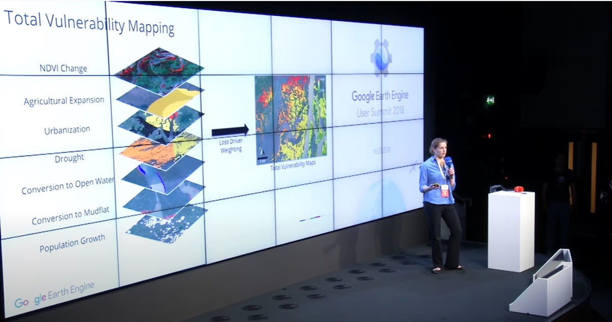
Stanford student Liza Goldberg, ’24, discusses climate change and satellite imagery at the 2018 Google Earth Engine User Summit in Dublin, Ireland. (Image credit: David Lagomasino)
To see environmental change over time, these satellites monitor the pulses of light emitted from different landscapes and objects on Earth’s surface – a process called remote sensing. With this data, researchers can then calculate ratios in wave-lengths of the reflected light.
“Using the energy emitted from these landscapes, we’re able to track how vegetation is changing over time, because healthy vegetation and unhealthy vegetation reflect radiation differently,” Goldberg said. “By measuring those changes in energy emissions, we’re also able to track trends like urbanization and deforestation.”
Researchers are able to access these satellite data for free using Google Earth Engine, a data platform for remote sensing analysis.
Goldberg and her fellow researchers introduced Cloud to Classroom last year at a conference in Lisbon, Portugal, for science educators. They’ve since traveled to cities worldwide to host trainings for teachers and students. Those trainings are now taking place online due to the COVID-19 pandemic. They expect soon to go live with an official website where students and teachers can access the apps for free.
“The long-term goal is to reach as many students as possible,” Goldberg said. “We’re looking to expand our work to several Latin American nations in the coming years.”
Working at NASA
Goldberg’s work on Cloud to Classroom began several years ago when she was growing up in Columbia, Maryland, near Washington, D.C. While presenting her work at a local science fair when she was in 8th grade, Goldberg caught the attention of one of the judges who worked at NASA and encouraged her to join the organization as an intern. She was just 14.
In high school, she would spend the first half of the day at school, before heading off to the NASA Goddard Space Flight Center, where she joined a team studying mangrove loss using satellite imagery from Google Earth Engine. Mangroves, which are one of Earth’s most valuable ecosystems because of their carbon-capture potential, have been in dramatic decline in recent decades.
“We’re working to create a system to monitor not only where mangroves are being lost, but also the primary drivers of that loss,” Goldberg said. Their findings were recently published in the scientific journal Global Change Biology. Goldberg is still working with NASA.
Feeling lucky to see Earth from a new perspective using satellite images to study mangroves, Goldberg wanted to share the experience with other students. So she approached members of the Google Earth Engine team in Mountain View with the idea of creating Cloud to Classroom.
“I just reached out to them and said, ‘What if we put these satellite technologies in the hands of not only scientists and researchers, but also the next generation?’ ” she said.
For her work on Cloud to Classroom, Goldberg was awarded a National Geographic Young Explorer’s Grant, which she’s put toward further developing the program. She’s hopeful that as it is integrated into more science curriculums, the chances of beating climate change will improve.
“The more students understand the science and impacts of climate change, the more quickly we can spread public awareness and jointly work toward climate solutions in the future,” she said.