7/11/96
CONTACT: Stanford University News Service (650) 723-2558
COMMENT: Paul Segall, Geophysics (415) 725-7241
e-mail segall@pangea.stanford.edu
Prepare for big ruptures on Hayward fault, scientists say
STANFORD -- Earthquake emergency planners in the San Francisco Bay Area should not assume that the next big quake on the Hayward Fault will rupture only its northern or southern segment. They should plan for a worst-case scenario with devastation along much of the fault's 50-mile extent. That is a major conclusion of a new study by Stanford geophysicists Paul Segall and Ellen Yu.
They devised a new method to glean data from 140-year-old geodetic surveys, to study the last major earthquake along the Hayward Fault, an 1868 temblor with a magnitude of about 7.0. They found that the earthquake ripped along the fault for at least 32 miles, from just south of Fremont to Berkeley. This is more than 30 percent farther than previously thought.
The Hayward Fault has long been charted with a southern and a northern segment. Many geophysicists expect such segments to slip independently and at different times. "This study should serve as a reminder that large quakes do not always stop at the supposed boundaries between fault segments," Segall said.
A report last April by the Association of Bay Area Governments predicted that, if the Hayward Fault broke in a 7.3 quake along its entire length from Fremont to San Pablo Bay, more than 150,000 homes would be uninhabitable throughout the Bay Area. However, disaster planning usually has been based on the assumption that only one segment of the fault would rupture.
Data collectors didn't know that quakes move mountains
The 1868 rupture toppled buildings from Hayward to San Francisco it was called "the San Francisco earthquake" until the 1906 great quake came along to steal the title. However, few people were living along the faultline at the time, and scientists' understanding of earthquakes was quite primitive. Since then, geologists have had to rely on scanty data to estimate how the fault actually performed.
In a study reported in the July issue of the Journal of Geophysical Research, Segall and Yu described how they used a long-overlooked source of scientific data about the Bay Area: the records of 19th century surveyors who measured the relative position of mountain peaks and hilltops throughout the region. The surveys were made in 1850 and 1880, before and after the 1868 quake.
That quake displaced the earth on either side of the fault by as much as six feet and thus changed the position of the landmarks in the surveys.
At the time, scientists had no idea that the earth is distorted by earthquakes in this fashion. Segall and Yu had to learn how the earth had moved, from "fixes" of longitude and latitude measured by people who believed the earth was in fact fixed. "It wasn't until 1906 that earth movements became large enough that they couldn't ignore it anymore," Segall said. "So for us, the challenge was that the 19th century surveyors assumed that once they measured something, it never had to be measured again."
Geophysicists work from the opposite assumption. "We don't care about precise measurement of where places are," Segall says. "We measure where they move."
Normally, graduate students in Segall's lab study up-to-the-moment earth movements, using global positioning system satellites to constantly measure and track the millimeter-by-millimeter creep of the earth along faultlines. Instead, Yu trekked to the National Archives in Washington, D.C. to study the dust-covered log books of the U.S. Coast and Geodetic Survey. The original purpose of those logs was to map major landmarks for ships navigating the California coast and San Francisco Bay.
The surveyors determined the position of landmarks by triangulation. Standing on top of a peak like Mt. Diablo in the East Bay, a survey team would use a telescope-based device called a theodolite to locate markers on two other peaks, for example on a ridge south of San Francisco and Mt. Tamalpais in Marin County. The three markers formed a triangle. By measuring the three angles of that triangle, they could establish the relative position of each peak.
Over several years in the 1850s and again in the 1880s, the surveyors mapped out a network of these triangles, locating positions throughout the Bay Area. They returned to some peaks several times, not to re-measure the same angles, but to take a fix on other peaks in the region.
Yu's and Segall's task was to take the raw data collected before the 1868 quake, compare it with the data collected in the 1880s, and use the angles to show them how much, and in which direction, the peaks had moved. "The mathematical trick we used was to write equations so they depend on things that we care about the displacement measurements as well as things that we don't care about the precise latitude and longitude," Segall said.
They used a projection operator, a technique of mathematical analysis that is common in statistics, but had never been applied to the problem of converting geodetic data to fault slip estimates.
The results fit best with this scenario: The quake struck with a magnitude of 7.0. The two sides of the fault slipped past each other slightly more than six feet. And the rupture broke through a section of the fault near San Leandro that geologists have long assumed to be the boundary between the fault's northern and southern sections.
Re-thinking fault segments
Geologists have long had proof that the 1868 quake slashed through at least 20 miles of earth from Warm Springs, south of Fremont, to San Leandro, because they could find evidence of the break near the surface.
Yu and Segall's data show that the rupture continued at least another 14 miles to Berkeley. That's as far as the data set goes there were no geodetic stations close to the Hayward Fault and north of Berkeley at the time but Segall says that the break may have gone beyond that point toward Richmond.
James Lienkaemper, an expert on the Hayward Fault at the U.S. Geological Survey, said he initially doubted Segall and Yu's results, but he has since dug up evidence to support it.
Lienkaemper studies past earthquakes by digging trenches that run across fault lines and studying the layers of soil in the trench walls. Laboratory tests determine the age of each layer. He found physical signs of the 1868 fault rupture while digging a ditch in Montclair City Park in Oakland further north than he expected, and evidence of a larger quake than estimated.
"It actually got almost to Berkeley. That caught me totally by surprise," Lienkaemper said. "We have to look with a whole new attitude towards interpreting the behavior of the Hayward fault."
Lienkaemper and Segall agree that the results of both their studies should help make scientists reconsider the importance of segments in faults. In the past, many geophysicists have assumed that the boundaries between those segments act as brakes to stop quakes from proliferating.
The 1992 Landers earthquake in Southern California was a "wakeup call" to proponents of this idea, Segall says. The segments of what is now called the Landers Fault were considered so separate that they even had different names, including the Camp Rock Fault and the Emerson Fault. "What happened at Landers is that this magnitude 7.3 quake went cruising through all those supposed segment boundaries. It stopped right in the middle of a big segment, so it violated the rules on two grounds," Segall said.
In 1868, the Hayward Fault appears to have done the same thing. For Bay Area residents and earthquake disaster planners, that means they must prepare for a worst-case earthquake that not only kills many people and devastates homes, roads and services, but wreaks its damage over a wide area.
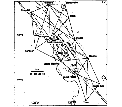
"Fixes" on a moving landscape: 19th-century surveyors used triangulation to establish the position of major landmarks in the Bay Area. Standing on one peak, they took sightings on two others and measured the angles of the triangle formed by the three. This survey was conducted in 1876-1891 by the U.S. Coast and Geodetic Survey. What the surveyors didn't know was that the peaks had moved as much as 6 feet during the 1868 Hayward Fault earthquake. Stanford researchers compared the results with an 1853-1860 survey to calculate that the quake ruptured at least 14 miles more of the Hayward Fault than previously thought.
-jb-
Barbra Rodriguez, a science writing intern at Stanford News Service, contributed to this release.
Additional World Wide Web links include: Journal of Geophysical Research at http://www.agu.org. An abstract of Segall and Yu's paper can be viewed at http://pangea.stanford.edu/~segall/1868_abs.html.
960711haywfault.html
Download this release and its related files.
The release is provided in Adobe Acrobat format. Any images shown in the release are provided at publishing quality. Additional images also may be provided. Complete credit and caption information is included.
960711haywfault.sit