1/16/96
CONTACT: Stanford University News Service (650) 723-2558
COMMENT: Paul Montgomery, Aeronautics/Astronautics (415) 322-1946
Prof. Brad Parkinson, Aeronautics/Astronautics (415) 725-4105
Model aircraft flies by itself using satellite navigation sensors
STANFORD -- Using a 12-foot model, doctoral student Paul Montgomery has shown that an aircraft can take off, fly a specified course and land automatically without relying on hundreds of thousands of dollars of sophisticated equipment.
It took him more than three-and-a-half years, but the Stanford aeronautics and astronautics student has managed to fully control a model aircraft using only the guts of a typical laptop computer, simple onboard wind speed and direction indicators, and receivers that track signals from Global Positioning System (GPS) navigation satellites - equipment that costs a few thousand dollars.
Low-cost automatically piloted aircraft might replace manned aircraft for purposes such as aerial photography, crop spraying and police surveillance. They also could be used in place of weather balloons for gathering meteorological data: Unlike weather balloons, they would not be restricted to certain altitudes. There are also a number of potential military applications.
"Paul has shown marvelous innovation in providing a very inexpensive solution," said Bradford W. Parkinson, the Edward C. Wells Professor of Aeronautics and Astronautics and Montgomery's adviser. "His results are startling, in the sense that he has shown the ability to perform precise control to better than a meter. This is noteworthy because it represents the next wave of GPS - accurate control using navigation satellites."
Montgomery's research is just one facet of a large program at Stanford designed to develop new GPS applications. Research at the GPS Laboratory, which comprises three faculty members and 22 students, includes efforts to develop a satellite-based, all-weather automatic landing system for commercial aircraft; a GPS-based system that can provide a regional or wide-area aircraft navigation and landing system; a pseudo-GPS system for robot navigation on the factory floor; and an auto-pilot for farm tractors based on satellite navigation.
Although the GPS-controlled aircraft has been Montgomery's project, he received substantial assistance from Hiro Uematsu, an engineering research associate at Stanford's Gravity Probe B project, and Andrew Conway, who recently received his doctorate from Stanford's aeronautics and astronautics department.
The first successful autonomous flight of the model aircraft took place on Nov. 27 at a special airfield for radio-controlled aircraft in Fremont, Calif. On that day and in subsequent flights, Montgomery showed that a technique called carrier differential GPS can provide the position information needed to control an aircraft with extreme precision. (Carrier differential GPS uses a signal from a ground station at a known location to increase the accuracy of the position that can be determined from the satellite signals.)
Before a flight, Montgomery programs into a laptop computer the path that he wants the aircraft to follow. This information then is downloaded into the airplane's onboard computer. After placing the plane on the runway and starting the engine, he pushes a single button, the aircraft takes off, flies the preprogrammed course and then lands all by itself.
Averaged over a kilometer course, the deviation in the aircraft's position from the programmed course was typically less than 0.5 meter horizontally, 0.25 meter vertically and 0.25 meters per second in air speed, Montgomery reported.
"Carrier differential GPS is accurate enough for most purposes, so you don't need a lot of expensive equipment," he said.
One of the biggest problems in using satellite navigation for this purpose is that as the plane banks and turns it can lose temporarily the signals from some of the satellites. Normally, six GPS satellites are in view at one time. A minimum of four is required to calculate the aircraft's position with the degree of precision needed to control it. To guard against falling below this number, test flights were made during periods when the maximum number of satellites was visible.
To address the problem of signal loss, Montgomery also equipped the small aircraft with a set of three inexpensive gyros that cost about $400. This kind of gyro normally is used for purposes such as stabilizing camera mounts. But Montgomery used them to keep track of the aircraft's attitude after it lost the GPS signal.
To test how well the gyros worked, Montgomery used the aircraft's remote control to perform a series of barrel rolls. In this maneuver the plane rotates through 360 degrees as if it were moving along the surface of a rotating cylinder. During this maneuver, the airplane typically lost GPS signal lock for five or six seconds. During these outages the gyros kept track of the airplane's attitude with sufficient accuracy so that when the GPS signals were reacquired the airplane's attitude could be reestablished without going through a prolonged period of computation.
"The gyros are complementary to the GPS. They are fast acting but have the problem of drift, while GPS is slower acting but does not drift," Montgomery said. "Much of the cost in making precision gyros comes from reducing drift. But if you use GPS information to continually calibrate the gyros, then drift isn't a big problem for the brief periods when the GPS signal is lost. That's why you can use low-cost gyros."
The system that he has developed lacks the "robustness" required for commercial applications, Montgomery said. But his work indicates that a system that combines inexpensive inertial instruments and GPS could have the added reliability that is needed.
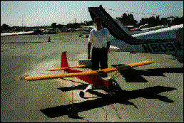
Paul Montgomery with model airplane
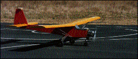
Model plane on runway
-dfs-
960116gpsplane.html
Download this release and its related files.
The release is provided in Adobe Acrobat format. Any images shown in the release are provided at publishing quality. Additional images also may be provided. Complete credit and caption information is included.
960116gpsplane.sit