|
March 21, 2012
From glovebox to archive: Private collector gives huge trove of road maps to Stanford
It is one of the most significant and comprehensive collections in the West – yet Robert Berlo's mother lode of 13,000 road maps began modestly with a young boy's cross-country trip to Boston. By Cynthia Haven
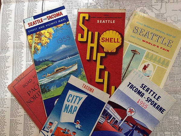
The Robert C. Berlo Road and Street Map Collection includes road maps, Forest Service maps, topographic maps, regional maps and city maps. (Photo: Dan Stober / Stanford News Service) The phrase "important map collection" conjures images of medieval maps with dragons spurting fire at the edges of the world or yellowed charts tracing vanished civilizations.
A 1964 Texaco road map of rural Oregon doesn't usually fit the ticket.
Yet Stanford University Libraries has acquired precisely that variety of maps in its newest acquisition – more than 13,000 of them. The Robert C. Berlo Road and Street Map Collection includes road maps, Forest Service maps, topographic maps, regional maps and city maps. Some were published by oil companies, others by real estate firms, and others by automobile associations, from the mid-1920s on.
Why maps?
Why would someone gather the detritus of yesterday's wanderlust? And why would a major research library want them?
"They're thought of as ephemera – a map that stays in the car and you use it until you throw it away," said Julie Sweetkind-Singer, head librarian of Stanford's Branner Earth Sciences Library and Map Collections. "They're still too new for people to think of them as old maps. There's a much larger market for maps that are 200 years old that have sea monsters in them."
Nevertheless, these maps have stories of their own: "It's a source of research information, just in a different format – a cartographic format instead of a text format," she said.
According to Sweetkind-Singer, "It's one of the most significant road map collections in the West – I don't know of any private collector who has a collection this extensive."
The Berlo donation augments the library's collection of 7,000 maps donated by the California State Automobile Association in 2009. The maps, which arrived at Stanford on March 12, will take more than a year to process and will be made available as they are catalogued.
Road maps from every state
"The biggest value of the Berlo collection is that it is comprehensive – it's so comprehensive in terms of its reach," said Sweetkind-Singer. "It includes an official state road map for every state in the union since 1927 to the present."
In short, they're a gold mine for researchers who study urban development, analyze land use development or investigate population growth in the West during the 20th century.
"These maps document a lifetime of dramatic change in the western United States and the nation as a whole as modernization steadily reached into every corner of the country," said Jon Christensen, the executive director of Stanford's Bill Lane Center for the American West.
"The Berlo map collection is an incredible resource for scholars of modern America and the American West in particular."
Berlo has been drawn to maps his entire life. In one golden year, 1966, he collected 502 maps; later, in 1985, he acquired 1,438 maps when he bought a collection in Oregon. (He carefully keeps track of all the numbers.) But the story began more simply, with a boy who wanted to know where he was.
Berlo was born and reared in San Francisco. In the postwar years, gas was cheap, families were growing and a cross-country trip in the old family Chevy promised adventure.
Road maps were freebies at gas stations, and tracking the trip could be a useful diversion and family entertainment in the pre-seatbelt days, when – in the Berlos' case – six of the seven boisterous children might be piled into one car.
The watershed occurred when Berlo was 11, and his uncle prepared 3x5 index cards for a car trip to a Boston family reunion. Berlo eventually continued the effort of recording the U.S. highways the family traveled and "listing every cotton-picking place we went to," recalled Berlo. He also recorded population figures on city border signs.
As a young adult he started hanging with "a few other people who were weird enough to collect old maps," including collector/dealers who had dozens of mimeographed pages listing maps for sale.
Maps and data
His growing collection was matched with his penchant for data gathering and analysis. He trained as a chemist, and later became a technical writer, a journalist and a publications manager at Lawrence Livermore National Laboratory.
"His gift is made all the more valuable by including his own extensive cataloging and research on the maps," said David Rumsey, who is donating his own map collection to Stanford.
The maps become more than just a collector's obsession. Berlo has published nine books about data extracted from his map and data collection – for example, the 738-page Population history of California places: an edited compilation and analysis of all known population figures for California cities, towns, counties, urban areas, and the state total, including the Spanish and Mexican era, Part 1.
Digitizing the maps
Stanford will digitize seven of the books, which include thousands of maps that Berlo has made himself. (He's gone even further in cartographic creation, drawing hundreds of "imaginary maps" by downloading topography maps and envisioning how a city or even a whole state would develop if there were a few more inches of rainfall a year, warmer temperatures or better soil.)
Map collecting may be a lost hobby; GPS and Google maps have displaced the paper guides in today's world, and Berlo said map societies are disappearing. "It may not occur to younger people nowadays to collect old maps," he said.
With illness, his thoughts turned toward finding a permanent home for the collection, and he chose Stanford. "It's pretty clear that Stanford has one of the best map collections around," he said. "Stanford is a leader in digitizing – and making them available to people."
One researcher is looking forward to the exploration: "I can't wait to send students into this rich archive for research," said Christensen, "and I am eager to take an archival, historical road trip in this collection myself someday soon."
-30-
|


