|
April 24, 2012
Stanford researchers work with Hawaii's largest landholder to plan an ecological future
The future of a large chunk of the island of Oahu was at stake when Stanford environmental scientists were called in to lend a helping hand. In the end, the environmental value of the land – not just the commercial value – was considered, and that made all the difference. By Katy Ashe
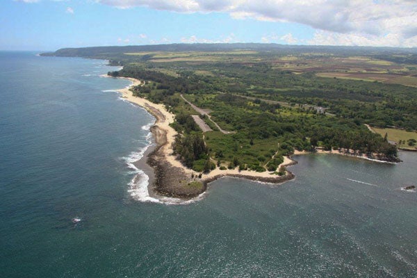
Kawailoa, the 27,000-acre land holding of Kamehameha Schools on the north shore of Oahu. (Photo: Josh Goldstein / Courtesy of Stanford University) Invasive vegetation crawled across barren farmland and the irrigation system fell into disrepair after the withdrawal of the sugarcane industry in 1996 from a 40-square-mile plot on the north shore of Oahu.
The abandoned farmland, part of a former sugar plantation, is owned by a trust, Kamehameha Schools, and it needed to be repurposed after a century in sugar cultivation. In 2006 the trust partnered with Stanford environmental researchers at the Natural Capital Project and embarked on a two-year process to determine the impacts of various land use alternatives, hoping to find the best use for the land.
Kamehameha Schools is no ordinary landholder. It is a philanthropic trust established as the dying wish of Princess Bernice Pauahi Bishop (the last living descendent of King Kamehameha I) with the mission of ensuring an education for all youth of Hawaiian descent.
Today the trust supports an educational system that serves approximately 30,000 children and is subsidized by the income generated on a diverse set of leases on endowed properties. These numerous properties add up to rank Kamehameha Schools as the largest private landowner in Hawaii, holding more than 8 percent of the state.
As such a major player, Kamehameha Schools takes its influence in the community seriously. The land-use decision-making process for the north shore of Oahu was a two-year formal conversation between the trust and the local community, with the formal mission to "balance environmental, economic, cultural, educational and community values."
Yet, despite best-practice methods, the trust didn't find it easy to turn the mission of environmental stewardship into something tangible. "Intuitively, you know what will be good for the environment, but that was all just based on faith," said the regional asset manager for the trust, Giorgio Caldarone. "We couldn't really quantitatively understand the trade-offs."
Enter Stanford
Stanford researchers from the Natural Capital Project teamed up with the trust to help determine the fate of the farm, with the goal of providing ecological models for decision-makers.
"It was a very organic process of figuring out what to model," said Stanford researcher Josh Goldstein, who led the study and is now an assistant professor at Colorado State University. "The trust was trying to capture the futures for the land that the community desired and we were trying to illustrate those stories. . . . We were turning stories into something very concrete that could help them make a decision."
Overall, the team spent two years working closely with the trust to help determine what should happen to the abandoned farmland. Team members spent time getting to know the fabric of the region, from the complex pressures exerted on local lands right down to the details of soil characteristics for every 90 square meters of the property.
Unprecedented pressures
As in much of the world, Hawaii is facing unprecedented pressures on its land base as an ever-expanding population demands residential and commercial development. At the same time, planners must grapple with a myriad of issues, such as food security, unemployment and environmental sustainability.
Ultimately, the decision broke down into three scenarios: growing sugarcane for fuel; diversifying agriculture and forestry; or selling the lands for a residential housing development.
The team used a Stanford software tool, called InVEST, that combined multiple layers of data embedded in digital maps and computed the outcomes, predicting the environmental and financial future of the land under the three scenarios. Team members used this method to create maps that illustrated the impacts on water quality, carbon storage and financial return for each scenario. The analysis is detailed in a paper that comes out today in the Proceedings of the National Academy of Sciences (PNAS).
"In many cases there isn't an easy win-win solution," said Goldstein. "You have to make trade-offs explicit so that purposeful decisions can be made." The trade-offs the scientists mapped helped inform the team at Kamehameha Schools as it reached a final decision.
"Scientists have been telling us about these impacts on land for decades," said Caldarone. "But this is the first time we can really use it in decisions." Ultimately, the model helped show some of the tangible benefits of certain land uses and led to the decision to make an environmentally sustainable choice.
Kamehameha Schools ultimately decided to reinvest in irrigation and use the land for diversified agriculture, including cacao, bananas and papaya. Its final plan for the north shore property received the American Planning Association's 2011 National Planning Excellence Award for Innovation in Sustaining Places. It didn't stop at agriculture; construction of a wind farm on the property should be completed by year's end. For the future, it is looking at the feasibility of small-scale forestry and biofuels on the property.
"A tool like this allows us to better communicate the ecosystem impacts of our decisions to both internal leadership as well as external stakeholders in a way that historically we were unable to," said Caldarone.
"Academics have talked for years about valuing nature," said Stanford biology Professor Gretchen Daily, "but we have been a long way from implementing it in a real way." The close work between the Natural Capital Project and Kamehameha Schools during this decision was a critical demonstration of the efficacy of this approach to land management. "This hadn't been done before, so we worked very closely with Kamehameha Schools to gain trust," she said.
The close partnership helped aid the birth of the Natural Capital Project. Since working in Hawaii the project has expanded into marine models, working on over 25 major engagements in 15 countries. In Latin America, InVEST is being used to establish national water funds, in which downstream water users compensate upstream landowners for improved stewardship practices. In China, approximately 25 percent of the country's landmass has been set aside as Ecosystem Function Conservation Areas (EFCAs), aimed at securing natural capital and alleviating poverty. InVEST is used to delineate and assess the best uses of the EFCAs.
The innovative Natural Capital Project is now ready to scale up. The new goal is to provide a more user-friendly version of the tool online, so that anyone making a land management decision has easy access. A free open source version is expected to be available to the public this summer.
Katy Ashe is an intern at Stanford News Service.
-30-
|


