
New interactive Stanford website presents unexamined data on federal programs that aid local governments in the American West
A team at Stanford created an interactive website to shed light on the money the federal government has paid to counties and states in the American West over time in turn for controlling parts of their lands.
To this day the U.S. government owns almost half of the land in the American West.
That level of control has been debated ever since the government began acquiring the areas in the 19th century, with some Westerners resenting the vastness of the federal authority, which amounts to 47 percent of land in 11 states. Some states, like Nevada, where the government owns 84.5 percent of the land, see more control than others.
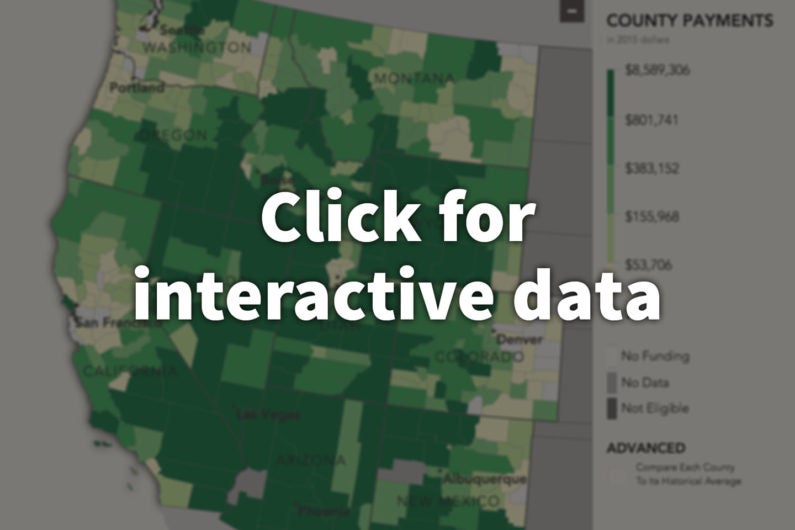
This Stanford site examines the history of revenue sharing based on public lands in Nevada and other Western states. (Image credit: Spatial History Project/CESTA)
But few know about the existence and history of revenue-sharing programs, with some dating to 1906, through which the federal government has been compensating states and counties for lost tax revenue on the lands it controls.
Now, thanks to historian Joseph “Jay” Taylor’s research and a team at Stanford’s Center for Spatial and Textual Analysis (CESTA), the history and geography of those programs are presented in Follow the Money: A Spatial History of In-Lieu Programs for Western Federal Lands, an interactive website that maps federal payments made to counties and states in the American West over the past 100 years.
“This project exposes material that’s never been published, let alone mapped before,” said Erik Steiner, co-director of Stanford’s Spatial History Project at CESTA.
Curious nature of land debates
The idea for the project started about five years ago when Taylor, who is a history professor at Simon Fraser University in Canada, was conducting research for his biography of a Colorado congressman who authored the Taylor Grazing Act of 1934.
While going through the congressional papers documenting that period, Taylor was intrigued to read about Westerners criticizing their federal bills and complaining about the loss of taxes to fund local social services, such as schools and roads.
“The Westerners did not, as some historians claim, oppose conservation,” Taylor said. “The arguments then weren’t about whether to conserve the lands. The battle was over local taxes.”
Those early debates in the late 19th century resulted in the creation of 10 “in-lieu” programs, which provided ways for the government to assist rural areas in the American West with revenue.
But when Taylor tried to look deeper into those programs, he didn’t find much – there were no academic studies.
“That sparked my curiosity,” Taylor said, “and it ended up being a giant rabbit hole.”
Taylor spent the next two summers in the basement of Stanford’s Green Library, filing Freedom of Information Act requests and asking state agencies for their accounting records as part of his fellowship at the Bill Lane Center for the American West.
The maps that tell a story
Once Taylor gathered some data on the programs, he turned to Steiner at CESTA. Steiner, a geographer who specializes in information design, collaborated with him on developing an interactive website to exhibit his work. Taylor and Steiner worked with CESTA GIS specialist Celena Allen and undergraduate students Krista Fryauff and Alex Sherman to bring the custom-programmed website to life. (See Undergraduate Training below.)
“The gathered data visualized through these maps illustrate how federal royalties actually funneled back to Western counties and states,” Taylor said. “This is the hidden fiscal civic history of these ‘empty’ lands. It’s a story that hasn’t been really told yet.”
The team hopes that presenting the data on these programs visually and making it accessible to the general public could inspire academics and journalists to do further research and inquiry into the poorly known fiscal relationship between the federal government and the Western states’ lands.
“That relationship for a very long time worked well and was quite popular with local and state representatives,” Taylor said.
But recently, the importance of that relationship has been misunderstood by Congress. In 2014, this misjudgment led to a brief termination of one of the revenue programs, the Secure Rural Schools (SRS) program, which was created in the 1990s to extend help to Western timber-reliant counties whose logging industries suffered after their forests became embroiled in lawsuits to protect habitat of threatened species, like spotted owls and marbled murrelets.
“It came down to this: Congress was cheap,” Taylor said. “SRS compensated counties for real problems, but it very quickly became labeled as a welfare program by conservatives and some environmentalists. Those groups expected local governments to magically come up with money for their social services some other way.
“The locals’ response to that essentially was: What are you doing? You’re impoverishing us.”
So the program was quickly restored in 2015, Taylor said.
Looking ahead
“These data could empower people to make more informed arguments from the patterns they see in our maps,” Taylor said. “The history and geography of these programs is remarkably uneven.”
But the data mapped out on the website, which Taylor has been painstakingly gathering during the past three years, represents only about 43 percent of available information on the 10 programs. A lot still needs to be collected.
“A big goal for the tool is to make the information transparent, though more data needs to be collected,” Steiner said. “The site is incomplete by design.”
The biggest challenge in data collection has been the federal government, Taylor said. While state agencies and local governments have helped Taylor extensively by digging up and scanning documents about the programs for him, the Department of the Interior, the Department of Agriculture and other federal departments have been largely unresponsive or unhelpful to his requests for information.
“We want to get people to contribute to the data collection,” Taylor said. “The more eyes we have on these materials, the better.”